Monday, June 25, 2012

We're burnin' daylight...

Thanks to the efforts of one of the hardest working crews I have ever been a part of, we have finished the stream surveys in the first watershed about two days ahead of schedule. Our days were long and breaks were held in check by Tony who, despite the inordinate amount of daylight surrounding the summer solistice, kept us on track by his ever-vigilant reminder, and now project mantra, "We're burnin' daylight."
Our fearless crew on day 1...
Essentially what we are doing for the surveys is walking upstream and collecting a bunch of data (coordinates of structures and features, bank width, water depth, bankside vegetation, stream bank and bed composition, gradient, fish trapping, etc.)  that will be used to classify the type of stream according to regional protocols. As we encounter tributaries we start the data collection over again for that tributary. The watershed we were in this last week is essentially a big bowl with steep slopes that has an inlet on the north side and an outlet on the south side. Numerous streams carved valleys throughout the bowl sides and allow for run-off from snow melt in the higher elevations. The inlet is fed in part by a higher elevation alpine lake and the outlet dumps into an ocean bay. The watershed is an important fishery for local communities and the data we collect should be beneficial in helping to protect the entire watershed and the fishery.
Setting fish traps...

Measuring pebble size...
Our home for the week turned out to be shared quarters with a fish weir crew at their camp that sits on the river between the lake and the bay. The camp has developed over years of operating the weir and includes a separate kitchen (complete with a refrigerator that was packed over terrain that is questionable without a load), sleeping quarters with plywood bunks, and DVD's via a TV powered by generators.
Home away from home...

Getting a canoe to the lake--not for the faint of heart. This is the path the refrigerator came down on the back of one of the weir crew...

Wildlife sightings were pretty slim and consisted of a few deer, plenty of deer sign, some bear tracks, typical regional birds, and one very protective family of gulls that dive-bombed us when we motored into a stream near their nesting area. We passed the nest that contained two young chicks in downy feathers hunkered down on top of a moss-covered log that protruded from the lake. The location provided protection from land predators; but, when we went by the following day the chicks were gone--presumably a snack for the numerous bald eagles that also kept the gulls busy.
Here today...gone tomorrow.
As usual in SE Alaska, the terrain provided some challenges. Once again our crew consisted of members who knew how to traverse the numerous downed logs and thick vegetation. Keeping up at times was a challenge for a relative flatlander like me (despite Tony's reassurance that I was in pretty good shape for a 240# guy), especially when crossing mossy, wet, and, therefore, slick logs that spanned streams.

I am smack dab in the middle of this picture holding a survey rod. The vegetation made taking measurements at any kind of distance difficult.

One of the numerous log bridges throughout the watershed.

We crossed the lake in a 12' boat (with an outboard that was also humped over the less-than-ideal trail) numerous times in our search for streams, the scenery was a definite bonus.


We encountered a few falls..
The valley where the stream enters the lake.

We surveyed this stream...at least until the gradient provided a barrier, which made for a rather short survey.
 For the remainder of this week we will be in Kooshtakah (a.k.a. Bigfoot) country...I will be sure to keep the camera ready.


Friday, June 15, 2012

Postholing in June...

Our search for goshawks this past week took us to a mountain lake--and a protected bay--about 35 miles southeast of Juneau. The lake is about 5 miles long and is approximately 550' above sea level. To get to the lake we hopped on a deHavilland Beaver--an omnipresent workhorse in Alaska--and took a 30 minute flight out of Juneau.


Once on the lake we were greeted by our camp personnel (a.k.a. bear guards), off loaded gear onto a skiff, and took a short ride to our camp. The camp consisted of a kitchen area, a wall tent, and a dome made up of a series of plastic discs set on a raised platform. The dome was our sleeping quarters--quite plush considering where we were. The entire camp was surrounded by an electric fence to deter any curious bears. Once we got settled in our dome, we got right to work and started our surveys.
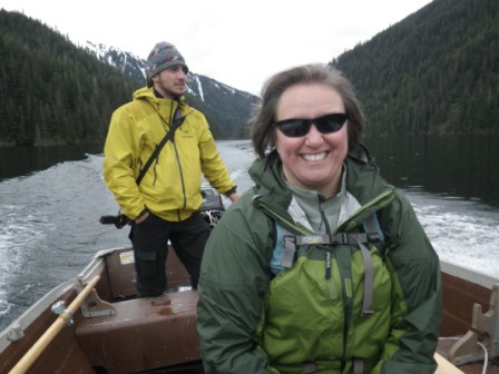
Kate and I realizing the GPS coordinates needed some adjusting...which hemisphere are we in?
Cathy being protected by Cameron, our very diligent bear guard/camp host.
On our way to the boulder field of death.
A few of our calling stations took us into an area that is strewn with boulders that ranged in size from a Mini Cooper to a double-decker bus. If it weren't for the snow the boulder field wouldn't have been an issue. Temperatures were warm enough that snow melt was pretty rapid; however, the snow around the boulders was rather deceiving and many times we would cross a snowy area not knowing how much support the receding snow could support. For the first time in my life I can honestly say, as each of my legs postholed to my upper thighs, I am glad my crotch ended any momentum.
Despite the difficulties with the boulder field, the views were fantastic.
Despite, or more likely, because of, the steep terrain surrounding a significant portion of the shoreline of the lake the scenery was quite breathtaking. We spent part of the surveys on foot and then switched to a canoe to reach some of the other calling points. Canoeing a remote lake has its perks.


Hard at work
After three days at the lake Cathy and I took a short plane ride down to the bay to continue with the surveys. We spent the next couple nights aboard a boat moored in the bay eating extremely well--meals included halibut and fresh crab prepared by a very generous host who also ferried us via a dinghy to the shore for our surveys. Within minutes of boarding the boat, the host pointed out a sow brown bear and her two cubs on shore--my first time seeing a wild brown bear.

The bay, to overstate the obvious, is at sea level. One thing I learned rather quickly this week is to really consider the distance between contours on a topographic map when planning a trip. Normally, back in Wisconsin, I am very content with 100' contours where slopes and gradients, as insignificant as they are, show up rather nicely. So, when I looked at the map of our calling stations and saw a "flat" area, I thought it would be easy work to make it to each of the points.
G1-G4 pretty much sucked...
As I am sure can be gathered, my skills at reading topographic maps needs some serious updating. Luckily for the two days that followed we were in the company of our bear guard who apparently moonlights as a mountain goat. Owen was born and raised in Juneau and has the type of intuition in the field that would make Magellan blush. I would give him a direction to our next point, throw in a distance, and he proved to me time and time again that the shortest distance between two points is not always a straight line--especially in SE Alaska. Even when we did get to a slope that even a rock would think twice about traversing, Owen would mentally map out a route that seemed impossible (and a radio call away from search and rescue joining us), step into the abyss--while keeping his thumbs tucked under his backpack strap and shotgun sling (for some reason, I kept picturing Johnny Appleseed as he made his way from town to town)--and casually, as if walking the paved streets of any southern Illinois town, saunter down the cliff (and I am not using the term cliff in exaggeration). Naturally we followed. Most of the time on our asses.
Even mountain goats need a quick nap.
As reward for our hard-earned changes in elevation--both ascending and descending--we were again rewarded with some great scenery.

Muskegs were numerous in the area and a nice reprieve from bushwacking.

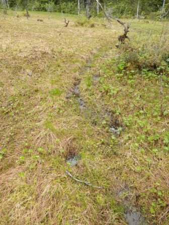
A well used bear trail in the muskeg.

Up next is Prince of Wales Island for two weeks to do more surveys in a couple remote watersheds. I will update as I can.

Friday, June 8, 2012

Back in Alaska...

So, I am back in Alaska for another field season. This time we will be spending a considerable amount of time camping since the two projects I am helping on are in spots that are a bit more off the beaten path. I have been here just over a week which started with a 3-day training session on Prince of Wales Island where, with the exception of about 6 hours, it rained the entire time. The rest of the time has been in Juneau where we have been purchasing required gear, finishing up some last minute logistics, and painting 1500+ wood chips an assortment of colors (more on this a bit later in the season).


We take a float plane out of Juneau tomorrow morning to start our first set of Goshawk surveys at a lake about an hour away. We will be working out of a base camp that sounds like it will provide relatively cushy conditions--complete with a wall tent, cooking capabilities, cots, and surrounded by an electric bear fence (which we have been duly instructed to avoid).

Following the first round of Goshawk surveys, I return to Juneau for a few days to wrap up logistics then head back to Prince of Wales for two weeks of trying my best to stay somewhat dry while conducting stream surveys in a couple watersheds near Hydaburg. We have a great local crew and I am excited to learn more about the ecology of the area from those who have spent their lives immersed in it.

Just as I did last time I was here, I will update as I can. Pictures will eventually follow. Unfortunately, I will be leaving my camera behind tomorrow because of weight restriction on our flight  but I will make it a point to take some pictures with our field cameras.